



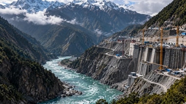
Chinese researchers have warned that runoff in the Brahmaputra River, known as the Yarlung Tsangpo in Tibet, could increase over the course of this century, potentially heightening flood risks in a region where China is building the world’s largest planned hydropower project, PTI reported.
According to a report by Hong Kong-based South China Morning Post (SCMP) on Monday, researchers from the Chinese Academy of Sciences and Yunnan University reconstructed the river’s runoff history from 1325 to 2020 using tree-ring width data from the southeastern Tibetan Plateau.
They combined the reconstruction with climate data to model future scenarios, which indicated that river runoff could increase alongside the frequency of high-runoff events, including floods.
The findings were published in the journal China Science Bulletin on October 8.
The researchers said the findings offered a long-term perspective on hydrological changes in the Yarlung Tsangpo basin and a scientific basis for assessing future water-resource risks.
They also called for future changes in runoff to be considered while planning water-resource development and storage infrastructure, as well as when assessing risks involving water resources shared across national borders.
The Tibetan Plateau has been warming at about twice the rate of the global average, affecting its ice cover and hydrological cycle, the researchers said. They added that changes in the river’s hydrological patterns could influence drought and flood conditions across South Asia.
The findings come as China builds a massive hydropower project in Medog, also known as Motuo, in southeastern , near the disputed border with India.
The project is estimated to cost $168 billion and is expected to have an installed capacity exceeding 60,000 megawatts upon completion, nearly three times the capacity of China’s Three Gorges Dam, currently the world’s largest operating hydropower plant by installed capacity.
The dam is planned in a deep Himalayan gorge where the makes a sharp U-turn before entering Arunachal Pradesh and flowing downstream into India and Bangladesh.
The project has drawn attention because of the region’s challenging terrain and seismic activity. The site lies near a tectonic plate boundary where earthquakes occur frequently.
In July, Chinese geologists warned that an active fault line directly beneath the planned dam could pose a threat to its structural stability. In a paper published in the journals Sedimentary Geology and Tethyan Geology, the researchers urged engineers to strengthen slope stability and introduce protective measures to reduce the risk of landslides and collapses, SCMP reported.
The concerns also come amid heightened attention to mountain hazards in the Himalayan region.
On August 26, flash floods along the China-Nepal border followed an ice-and-rock avalanche and the subsequent collapse of a temporary river blockage. The disaster reportedly killed nearly 1,500 people and left more than 5,500 missing in Nepal and China.
The Brahmaputra originates in Tibet and enters India through Arunachal Pradesh, where it is known as the Siang before being called the Brahmaputra further downstream.
China has previously defended the hydropower project, with its Foreign Ministry saying it would not affect downstream countries and that safety concerns had been addressed through decades of studies and safety measures.
The latest research highlights the potential implications of changing runoff patterns for water-resource planning and flood-risk assessment across the transboundary river basin.