



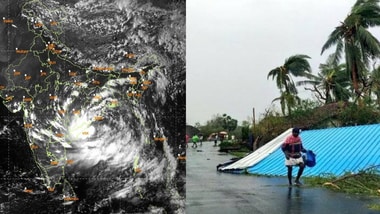
Cyclone Arnab: A deep depression over the Bay of Bengal is strengthening and moving towards the eastern coast of India, with the forecasting further intensification before it reaches the coastline of Andhra Pradesh and Odisha. IMD on Tuesday said the low-pressure area over the Bay of Bengal had intensified into a depression and was likely to become a deep depression within the next 10 hours.
The weather system over the West Central and adjoining Northwest Bay of Bengal moved westwards at a speed of 18 km per hour and lay centred over the same region at 8.30 am, it said.
“It is very likely to cross the north Andhra Pradesh-South Odisha coasts between Visakhapatnam and Gopalpur as a deep depression during the night of September 23-24,” the department said in a press release.
As of 1 pm, the depression lay about 290 km east of Visakhapatnam.
Under the influence of the depression, the department forecast heavy rains at isolated places in parts of Andhra Pradesh from September 22 to 25.
The India Meteorological Department forecast heavy rainfall at isolated places in Coastal Andhra Pradesh, Yanam and Rayalaseema.
Bay of Bengal depression intensifies, moves towards Andhra Pradesh-Odisha coast
According to the IMD’s latest update issued on Tuesday, the depression over the westcentral and adjoining northwest Bay of Bengal moved westwards at a speed of 8 kmph during the preceding six hours.
At 11.30 am IST on 22 September, the system was centred near latitude 17.9°N and longitude 85.8°E. It was located about 180 km south-southeast of Gopalpur in Odisha, 180 km east-southeast of Kalingapatnam in Andhra Pradesh, 210 km south of Puri in Odisha and 270 km east of Visakhapatnam in Andhra Pradesh.
The weather system is expected to move west-northwestwards and intensify into a deep depression over the westcentral and adjoining northwest Bay of Bengal during the next 12 hours, the weather office said.
The IMD has forecast that the will continue moving west-northwestwards before crossing the north Andhra Pradesh-South Odisha coast between Visakhapatnam and Gopalpur.
The landfall is expected to take place as a deep depression by the night of 23 September, according to the latest forecast.
The system’s proximity to the coast is likely to increase the risk of adverse weather conditions across coastal districts of Odisha and Andhra Pradesh as it approaches land.
Odisha and Andhra Pradesh are expected to be among the areas most directly exposed as the depression approaches the coast. Coastal locations around Gopalpur, Puri and Kalingapatnam, as well as areas near Visakhapatnam, are particularly relevant to the system’s projected path.
The developing system may also influence weather conditions across parts of West Bengal, depending on its subsequent movement and interaction with land after crossing the coast.
Residents in coastal and adjoining districts should follow the latest advisories issued by the IMD and local authorities as the system develops.
The IMD said the depression is very likely to move west-northwestwards and intensify into a deep depression during the next 10 hours.
It further said the system is very likely to maintain its west-northwestward movement and cross the north Andhra Pradesh-South Odisha coasts between Visakhapatnam and Gopalpur as a deep depression by the night of 23 September.
The forecast path and intensity can change as the system moves closer to the coast, making subsequent IMD updates important for residents and authorities in the affected areas.