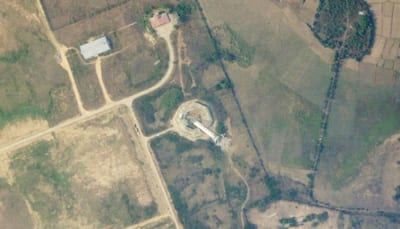
The satellite images from Planet Labs PBC analysed by Associated Press (AP) show that the air traffic control tower at Naypyitaw International Airport collapsed in the devastating earthquake that hit Myanmar.
As per the AP report, the images were taken on Saturday and they show the tower toppled over as if sheared from its base. Debris lay scattered from the top of the tower, which controlled all air traffic in the capital of Myanmar.
It was also reported that there was no immediate clarification if there were any injuries in the collapse, but there would have been staff inside the tower when the earthquake hit. This would have also halted the air traffic into the airport.
> A satellite photo from Planet Labs PBC shows a collapsed air traffic control tower at the Naypyidaw International Airport on Saturday, after an earthquake struck in Naypyidaw. All six airport employees in the tower have died …
— MIBAWI (Michael Barthel) (@RealMiBaWi)
On Saturday, India delivered 15 tonnes of relief material and dispatched more supplies by air and sea along with rescue teams under the emergency mission ‘Operation Brahma’, as per PTI.
Over 1,000 people have lost their lives in the colossal quake of 7.7 magnitude that hit Myanmar on Friday and caused a huge deal of damage to infrastructure.
On Saturday, A 5.1 magnitude earthquake struck Naypyidaw, the US Geological Survey (USGS) reported.
Stay informed on all the , real-time updates, and follow all the important headlines in and on Zee News.


