



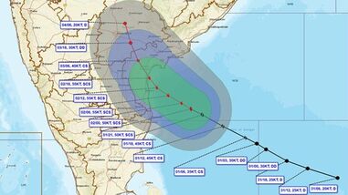
Less than a week after Cyclone Arnab, another deep depression over the Bay of Bengal intensified into a cyclonic storm on Sunday, leaving southern India on high alert for heavy to very heavy rainfall over the next three days.
According to the India Meteorological Department (IMD), it will make landfall on the morning of November 3 between Nellore and Narsapur in , with wind speeds of 100-110 kmph, gusting to 120 kmph.
This cyclone has been named ‘Murasu’ by India, meaning war drum.
The previous cyclone to hit the Andhra Pradesh coast and neighbouring was Arnab. It had wind speeds up to 150 kmph when it made landfall on October 28.
The weather agency, in its latest update, said the deep depression has intensified into severe cyclonic storm and as of today, lay centered over the same region — about 260 km east-northeast of Chennai (Tamil Nadu), 290 km east-southeast of Nellore (Andhra Pradesh), 320 km south-southeast of Machilipatnam (Andhra Pradesh), 310 km east-southeast of Kavali (Andhra Pradesh), 330 km southeast of Ongole (Andhra Pradesh) and 470 km south of Vishakhapatnam (Andhra Pradesh).
The IMD said that, under the influence of the system, isolated extremely heavy rainfall is likely over Coastal Andhra Pradesh and Yanam on November 2, followed by isolated very heavy rainfall on November 3.
The Met Dept also predicted isolated heavy rainfall in Puducherry and Karaikal on November 2 and 3; in Kerala and Mahe from November 1 to 4; and over Coastal and North Interior Karnataka on November 3.
Manorama Mohanty, the director of the meteorological centre in Bhubaneswar, said Odisha will receive rainfall from November 2, with intensity increasing on November 3, continuing through November 4 under the cyclone’s influence.
The state has already sounded a high alert in the southern region, including Ganjam, which was severely hit by .
Tamil Nadu to remain on high alert after the Regional Meteorological Centre warned of heavy to very heavy rainfall over the next three days.
On November 2, heavy to very heavy rainfall is forecast at isolated places in Chennai and Tiruvallur, with heavy rain continuing in Chengalpattu, Kancheepuram, Ranipet, Vellore and the Nilgiris.
The intensity is expected to taper off on November 3, with heavy rain confined to isolated places in the Nilgiris.
“Depression over southeast Bay of Bengal and adjoining areas of Andaman and Nicobar Islands intensified into a deep depression and into the cyclonic storm ‘Murasu’ on Sunday,” the RMC said on Sunday.
“It is very likely to move west-northwestwards and intensify further into a severe cyclonic storm over west central Bay of Bengal around November 2 morning. Thereafter, it is likely to cross south Andhra Pradesh coast between Nellore and Narsapur in the early hours of November 3,” it added.
The Meteorological Centre, Hyderabad, has issued orange and yellow alerts for several districts in the southern region for November 2.
An orange alert warning of heavy rainfall has been sounded for isolated places in Khammam, Nalgonda, Suryapet, Mahabubnagar, Nagarkurnool and Wanaparthy districts of Telangana.
A yellow alert has been issued for Jangaon, Yadadri Bhuvanagiri, Rangareddy, Hyderabad and Medchal-Malkajgiri districts of Telangana.
Thunderstorms accompanied by lightning and gusty winds of 30-40 kmph are very likely at isolated places in Khammam, Nalgonda, Siddipet, Yadadri Bhuvanagiri, Rangareddy, Hyderabad, Medchal-Malkajigiri, Mahabubnagar, Nagarkurnool, Wanaparthy, Suryapet, Mahabubabad, Warangal, Hanamkonda, Jangaon, Vikarabad, Sangareddy, Medak, Kamareddy, Narayanpet and Jogulamba Gadwal districts of Telangana.